
One of the most
intimidating spots in the Smokies is near the top of Mount Kephart, where the
Appalachian Trail and the Boulevard intersect. Near this junction there’s a
side trail that leads about half a mile, past the actual summit of Mount
Kephart, to the eastern edge of this mountain. Yes, the eastern edge.
When speaking of
the Smoky Mountains, the word “edge” probably seems out of place. There aren’t
a lot of edges in the Smokies because the southern Appalachians tend to have an
old, rounded look to them. It seems that all the sharp edges have been worn
off, and that’s mostly true for most of the park, but there are sections of the
park where that is definitely, dramatically, unequivocally not true. One region of sharp edges is the bowl formed by Mount
LeConte, The Boulevard, and the AT to Charlies Bunion and the Sawteeth. These
sharp edges were all formed by some sort of erosion, sometimes gradual but
often sudden landslides caused by a heavy rain. Occasionally human abuse (such
as 1920s logging followed by forest fires) contributed to the landslides, but ultimately
the underlying culprit is the fragile slate that provides a weak base for the
accumulation of soil on these slopes.
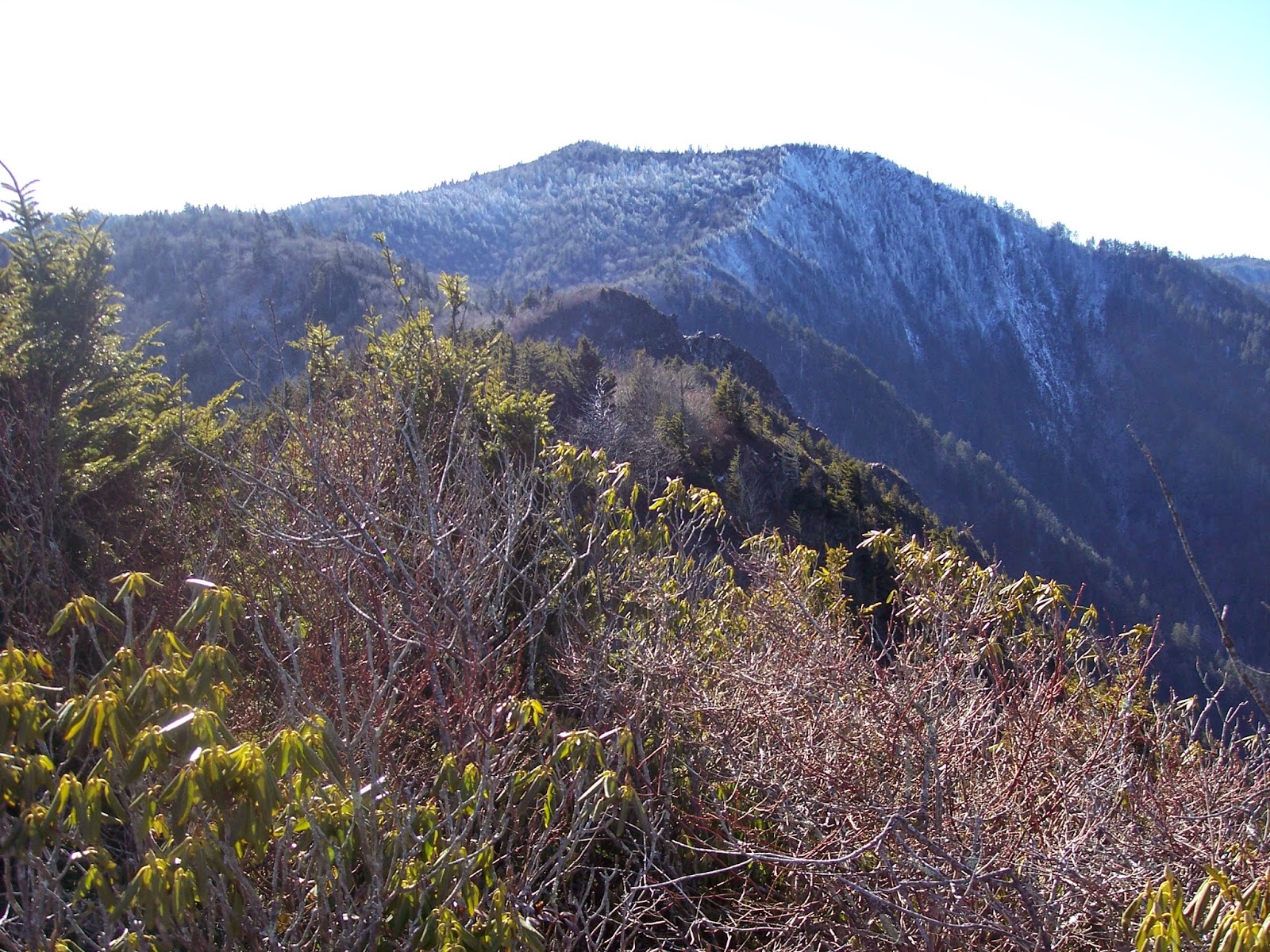 |
| The "edge" of Mt. Kephart (aka The JumpOff) |
Right in the
middle of this bowl stands Mount Kephart with its steep eastern edge, the top
of which is called The Jumpoff. I suppose I could spend a paragraph expounding
on the meaning of that name, but it’s probably pretty obvious: it’s high and steep.
Of course, many
places in this LeConte-Boulevard-Bunion bowl could be called the Jumpoff, but
the name was apparently attached to this particular location by the Smoky
Mountains Hiking Club. One of the most obscure, but interesting,
Smokies-related documents I’ve ever encountered is the script of a skit that
was put on by several members of the SMHC in 1944 celebrating and reminiscing
about their first twenty years of existence. These old, yellowed papers were
passed down from Dutch Roth (one of the SMHC’s first members) to his daughter,
Margaret Ann, and to her brother’s son, Charlie Roth, who is one of my regular
hiking buddies. In one scene of the skit, one of the actors (probably Guy
Frizzell) commented:
Did
you know the Hiking Club had a part in naming a lot of places on the state line
and the Tennessee side of the Smokies? Yeah, four of our members and Hodge
Mathis of Johnson City were designated as an advisory committee to the U.S.
Geographic Board of Names. Jim Thompson was chairman and Brockway Crouch,
Robert L. Mason, and Paul Fink were the other members. They collected folk
lore, old maps, talked with the old-timers of the mountains – I remember Andy
Gregory was a big help – and then they recommended the adoption of names most
generally accepted; but in many instances there were duplications to be
avoided. There were Big Creeks, Mill Creeks and Fork Ridges everywhere. Well,
this gave the Committee an opportunity to slip in some real old Hiking Club
lingo, such as “Wooly Tops,” “Boulevard,” “Charlie’s Bunion,” and “The
Jump-Off.”
Yes, Jumpoff was
the name that the SMHC used among themselves to describe this high, eastern
edge of Mount Kephart.
My three hiking
partners and I have had the experience of hiking in some out-of-the-way places
– ridges, creeks, and cascades that have no names. For awhile we have to
stumble around whenever we talk about them, saying things like, “the path that
starts at Tremont and goes to Thunderhead” or “the big cascade a half mile
above Ramsey Cascades,” but we eventually settle in to using names that emerge naturally
out of the conversations, without forming a committee and taking a vote. So,
the old path from Tremont becomes Thunderhead Prong Trail, the cascade above
Ramsey Cascades becomes Upper Ramsey, the rocky overlook a quarter mile east of
Charlies Bunion becomes the Rocky Crag, and the three tributaries feeding
Lester Prong above Porters Creek become First Trib, Second Trib, and Third Trib,
starting low and moving upstream because that’s the direction we normally
travel when we explore the Lester Prong watershed… [To be continued].
No comments:
Post a Comment