Monday, December 29, 2014

The Land of Sharp Edges (5 of 9): The Jumpoff Cascade


As we worked our way up the Jumpoff, we spent more time in the moss and bushes than we spent in the creek because the creek was now a long, winding cascade which was too steep and slippery for us to trust. Only occasionally could we get in it and climb directly on its rocky path and even then only on segments that were ten or twenty feet high – if any higher, a slip and slide would be long and painful, maybe deadly.

The result was a long, slow ascent as we grabbed and pulled and pushed and rested. Repeat, repeat, repeat. The next day, as I recuperated from our adventure, my legs and arms were a little sore, but the body part that suffered the most was my fingers. The muscles in my fingers were almost too sore for me to grip door knobs, write with a pen, and type on a keyboard. I’ve never seriously pondered the fact that there are muscles in our fingers, and to the best of my recollection I’ve never done any activity that actually made my finger muscles sore… until the grabbing and pulling of this trip. From now on I guess I’ll have to put finger exercises into my workout routine; although, I have no clue what kind of exercise to do to get a good finger workout; maybe kneading bread dough or digging in sand. Is there such a thing as finger curls? It’s a question that personal trainers probably aren’t asked very often because finger muscles aren’t glamour muscles. Rock climbers, on the other hand, would know the value of a buff hand.


This was the first trip on which I wore gloves. A couple of recent, off-trail trips had resulted in some damage to my hands and wrists. I normally get some bumps and bruises, but on one of these trips I had managed two good cuts on my hand and wrist. I don’t know how I got them. In fact, as I recall, Charlie and Keith asked where I got the bloody cuts, and I couldn’t tell them because I hadn’t noticed until they pointed them out. Although, I suppose I would have noticed sooner or later because one of them wouldn’t stop bleeding. As a result, I have some good pictures of me wearing a blood-stained shirt. It looks worse than it really is which is the way I like things to be – that is, not as bad as they seem. The cut on my wrist didn’t bleed a lot, even though it was deeper and longer. In fact, Keith called is a “laceration” which had a nice, manly ring to it, but again it sounded worse than it really was.

So, after that trip, I began wearing gloves on some of these off-trail jaunts. Some guys wear stout, sticky gloves like NFL receivers wear, but I opted for a $13 pair of leather work gloves from Wal-Mart, and in this case that seemed somehow appropriate. Not only were these gloves less expensive, but they had a simple “going to work” appearance that I kind of like because some of these hikes are a lot like work, even to the point of looking forward to quitting time when you can go home and take a shower. My hiking partners use headlamps on our night hikes and Charlie wears protective goggles on some of these trips, so between headlamps, goggles, and gloves we look like a gang of laborers heading down into the coal mines. All that’s missing are lunch pails and hard hats.
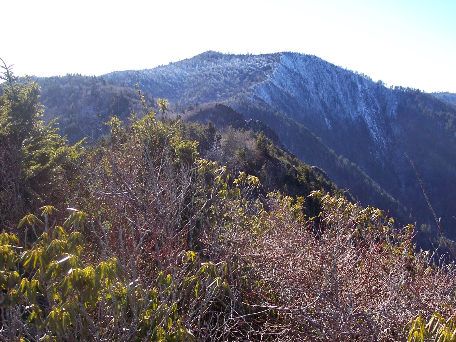
This cascade, which we now call the Jumpoff Cascade, went on and on and on. One hundred feet, two hundred feet, one football field. More climbing. Four hundred. Five hundred. Two football fields. More climbing. Seven hundred. During the climb we didn’t know exactly how long this cascade extended, but we made a pretty good guess based on elevation and angle. Greg, Keith, and Charlie all had altimeters which measure elevation using barometric pressure. Their equipment all pretty much agreed that after 1,000 feet of vertical elevation gain, we came to a split in the cascade. We had ascended vertically 1,000 feet at roughly a 45 degree angle, which would mean our horizontal distance was about 1,000 feet as well. Using the old Pythagorean Theorem from high school geometry class for calculating the hypotenuse of a right triangle, we came up with an estimate of about 1,400 feet. Up to this point, this cascade – which still continued up both of these small forks at this junction – was 1,400 feet long!


To grasp the significance of that, consider that Ramsey Cascades, one of the most popular waterfalls in the park, is about 100’ high. Abrams Falls, another visitor favorite, is about 30’ high. Yes, these two waterfalls have much greater volume and width than Jumpoff Cascade, which at this high elevation is generally just a heavy trickle… but 1,400 feet for cryin’ out loud! And it continues another one or two hundred feet up both of these upper forks on Mount Kephart.


It’s discoveries like this that make hiking in the backcountry really special. There are hidden, rarely-visited waterfalls and cascades all over the park: Mill Creek, Upper Ramsey, Cannon Creek, First Trib. They are everywhere, and in terms of sheer length, Jumpoff Cascade dwarfs them all.


Monday, November 24, 2014

The Land of Sharp Edges (Part 4 of 9)


So six months after Greg’s initial trip, when temperatures were at a more civilized level, all four of us (Greg, Keith Oakes, Charlie Roth, and I) did the Lester Prong-Jumpoff trip. While the name Jumpoff has some glamour, the name Lester Prong doesn’t. It sounds tame, even to the point of being a bit dorky. I don’t want to offend anyone out there who’s named Lester, but there’s a reason why wrestlers and other celebrities name themselves Rock, Diesel, Bono, Sting, even Ray or Jon, but never Lester. (To avoid the appearance of conceit, let me hasten to say that I fully understand that they don’t name themselves Greg, either.) It’s just not a name that conjures up images of bravery and excitement. But Lester Prong is anything but tame. Yes, it’s small – it would be nearly impossible to drown in it – but it wouldn’t be hard to fall to your death. If I had been on that advisory committee, I’d have suggested Deathwish Prong, only because Styx Branch (you know, the river that flows through Greek hell) was already taken by a creek on the other side of Mount LeConte. 

 
Lester Prong, Below 4,700'

After hiking up Lester Prong for about half an hour, we began to see car, truck, and trailer sized tangles of debris – trees and rocks – in the creek. This is always a sign of a landslide, usually the result of a sudden, heavy rain that saturates the ground and pulls several acres of soil off the mountain side, bringing tons of rocks and trees with it. This conglomeration will ride its way downstream as a wall of mud, wood, rock, and water, eventually slogging to a halt and creating huge tangles in the river valley. 

Debris Field on Lester Prong
 
After a few hundred yards of these tangles, which got bigger as we moved further upstream, we came to a fork in the creek around 4,700’ elevation, about 1,300’ below the Jumpoff directly above us. The line of debris flowed from the right branch, showing that this most recent landslide had come from that direction, near Horseshoe Mountain to the north. The left branch had a long, thin, scoured look with only a few loose rocks and a modest stream of water running down the middle, meaning that if we were going to follow Lester Prong as far as possible, this was the fork we would take.

So we did.
 
But it wasn’t easy.

 
Starting up the left fork at the 4,700' split

This was the point where our hike changed from a feet-only affair to feet -& hands because this left fork was slippery and steep. Later we calculated that the overall incline of this section was about 45 to 50 degrees, which doesn’t seem difficult on paper, but on the ground it’s tough because this 45 degree incline is an average. There would be ten or twenty feet of 60+ degree incline followed by a few feet of maybe 10 or 20 degrees, followed by another ten or twenty feet of steep, wet cascade, followed by a few feet of easy stepping. The result is mostly hands and feet climbing, with only a few brief reprieves. Did I mention the fact that water has been flowing over this bed of slate since time immemorial? So it tends to be a bit on the smooth, slippery side of things with very few sharp, strong hand and footholds. The result is that we spent much of our time a few yards to the side of the cascade, alternately pushing and pulling our way through a thick layer of green, wet, soft, loose moss, plus a lot of roots and branches.

 
Jumpoff Cascade, about 5,000'

In this kind of climbing, our most trusted allies are spruce trees. We can trust these trees and their roots with our lives; although we try not to put ourselves in that position very often. Whether climbing up a steep, rocky bluff or through a steep thicket of shrubs and trees, it’s best to keep your weight evenly distributed among your four points of contact – two hands and two feet – but occasionally it’s necessary to put all your weight on just one point. I will rarely do this on a rock surface but will resort to it upon occasion if I can use a root or branch – but only healthy spruce trees. They are always strong and sturdy, which is something I can’t say confidently about birch, rhododendron, mountain laurel, and the dozens of other bushes that grow on these steep slopes.

A close second is sand myrtle which is a small, leathery bush that often grows in the cracks of very acidic, rocky terrain, which is exactly what the ridges and cliffs of the Land of Sharp Edges consist of. We won’t put all our weight on a single sand myrtle the way we would a spruce root, but we can use a sand myrtle bush to pull ourselves up with as much or more confidence than we place in the rock itself, simply because the rock is fragile, Anakeesa slate that sometimes breaks off in your hand when you pull on it. The sand myrtle that grows in the cracks of these walls of slate really is more trustworthy than the rock it grows on.
 
Rhododendron is a distant third. Apparently its roots aren’t designed to dig deep into cracks in the rock, so these plants – which seem strong and rubbery at lower elevations – are often weak or dying on these high, rocky slopes. Only occasionally can they be trusted as a secure hand-hold. Mountain Laurel – rhododendron’s close cousin – is a bit too brittle and breaks too easily. So we tend to use the laurel and rhody to help us keep our balance when we need just a little extra help in leaning the right direction. It’s like holding on to a handrail as you go up a flight of stairs. You don’t need it to support your entire body weight; you only need it to provide a little support to help you keep your balance. [To be continued]

Thursday, October 30, 2014

The Land of Sharp Edges: “Park at Porters…” (Part 3 of 9)

While my three hiking partners and I had been talking for months about exploring Lester Prong all the way to the base of the Jumpoff, Greg Harrell was the first to actually do it. Of the four of us, he’s the one most likely to hike off-trail by himself. He may even prefer to go by himself; although, he hasn’t come right out and said so, probably because none of us have come right out and asked. It’s just generally understood among us that on any given Sunday, Greg may show up at church with tales of a Saturday hike that took him to some place that none of us had yet explored. He has topo maps at home with mysterious blue lines that he’s drawn up and down and across and along dozens of obscure creeks and ridges. It’s his three dimensional, Smokies “to do” list. To keep him from doing all these new trips without us, we’ve had to pressure him into solemn pacts with us – promises that none of us will explore Eagle Rocks or the Cat Stairs or some unnamed ridge until all of us are able to go. But we don’t have a pact for every blue line, so he takes off without us every now and then.

Greg seems to have a special “death wish” gene that the rest of us don’t have. The fact that he visited the Jumpoff by himself suggests the presence of this genetic defect. The fact that he went in February confirms it. Now we’ve all done February hikes before, and they are usually uncomfortably fabulous. You just have to put yourself in the right frame of mind by embracing the cold weather as a point of pride rather than discomfort. However, the thing that puts Greg’s initial Jumpoff trip in a special category is that much of it involves a wet, river hike – and by “wet” I mean hiking in the river. Not near the river. Not by the river. In the river, ankle to knee to waist deep. Yep, there’s definitely a genetic defect lurking under the surface. If it weren’t such dangerously bizarre behavior, he’d have our respect for such foolishness.

Like most of his hikes, the description of this one begins like this: “Park at Porters Creek ….” Greg seems to enjoy the fact that you have to hike almost four miles to the end of Porters Creek Trail before the real adventure begins. From the end of this trail there’s an old path that leads even further along Porters Creek, crossing it several times, and eventually crossing Lester Prong which flows into Porters from the southwest.

Actually, there are a couple of old paths, and the one that parallels and crosses Porters Creek is the less visible of the two. In August, 2009, a 70 year old, experienced hiker parked at the Porters Creek trailhead, hiked the four miles on Porters Creek trail and intended to continue on this old path along Porters Creek. Somehow he managed to lose this path, and instead of working his way up Porters Creek, he ended up lost and on the top of Porters Mountain, where he camped for several days until the search and rescue team found him.

My partners and I have been up this route many times. In fact, it was one of the first off-trail trips that we discovered in the Smokies. While I don’t know exactly how the hiker got off track and lost, I can visualize several spots where it could have happened. The most likely is at the end of the official trail, by the Porters Flats backcountry campsite, also known as Campsite #31. At this spot, the old path continues to the left, but within about a minute there’s a barely-visible split. At this split, the less-obvious, less-visible path to the right leads along the creek. The more-obvious, more-visible path bears to the left and heads up the western slope of Porters Mountain. After sending you up this slope, this trail quietly, calmly disappears. If you continue upslope, hoping to rediscover the trail, you’ll end up in the rhododendron thickets and rocky ridge of Porters Mountain. Without a good map and compass, at this point you’ll probably be lost. On the other hand, if you can figure out where you are, you can push your way along the ridgecrest to Porters Gap on the Appalachian Trail. I’ve done that trip once. I don’t intend to do it again. We weren’t lost, but we were roughed up a bit. It took over a week for my cuts and bruises to heal.

Of course, today we’d be avoiding Porters Mountain. We’d follow Porters Creek along the old, barely-visible path. Staying on this old path will lead you up the rough, slippery creekbed of Porters Creek to the Appalachian Trail on the main ridgecrest, near Dry Sluice Gap. But things get even rougher and more interesting if you hop off this path and slosh your way up Lester Prong because Lester Prong leads eventually to the Jumpoff.
 
One of the many beautiful cascades on this Porters/Lester trip.
 
Website Only:
 
Here's the important detail to avoid unnecessary wandering: At the small wooden #31 marker at the end of the official trail, bear to the left. (Right goes to the campsite.) Once you bear left at the wooden marker, you'll almost immediately cross a small gully (sometimes water, sometime dry). Immediately on the other side of the small gully, turn right. Don't go straight. That's the same mistake the guy who got lost on Porters Mountain made in 2009.  So, if you'll turn right after the gully, you'll be on a pretty well-worn path that is the Porters Creek manway. If you'll follow the path, you'll be fine. There will be places where you won't be sure where to go as the path gets light or crosses the creek. At those places, look around for the small rock cairns. They are always exactly where and when you need them. It's a great hike. After about 45 minutes or so there's a quasi-obvious split in the creek. The right is Lester Prong. The left is Porters Manway (aka Dry Sluice Manway) which leads up to the AT near Dry Sluice Gap.

Thursday, October 2, 2014

Land of Sharp Edges (Part 2 of 9)

 
Little cliques of hikers have been giving their own names to their personal stomping grounds for years. For example, I’ve heard some folks speak of the Real Charlies Bunion, the Tourist Charlies Bunion, the Boobs, and No Name Ridge – all names that have no meaning outside the insiders of those groups. Because this process of naming happens so naturally, I’d bet the farm that this same thing has been going on since the beginning of time. Ancient hunter-gatherer tribes undoubtedly encountered rivers and waterfalls and gave them their own, common-sense names. If a tribe’s first encounter with a watering hole resulted in killing a panther, then that watering hole might forever be Dead Panther Spring. On the other hand, if the panther got the better end of the deal, it might henceforth be known as Dead Hunter Spring. Either way, the names evolve out of common use based on real life (Panther Springs, Mill Creek) with an occasional flourish of creativity (Jumpoff) or humor (Charlies Bunion).

Giving permanent, official names to rivers and mountains is a relatively new phenomenon in American history which began only as outsiders in the form of explorers, scientists, and government officials encountered these remote places. These ambassadors of civilization had to standardize the names so they would know which rivers and ridges they were talking about amongst themselves for the purposes of navigation, boundaries, and ownership. You can’t make a good map of your domain without names for the places you are mapping. In the Smokies, this process didn’t happen until the 1930s as the old pioneer names were replaced by a different, official set of titles, and apparently only those groups of hikers or hunters who are appointed as advisory committees to governmental boards will ever have the chance to emblazon their place names on an official map.

So “Jumpoff” provides a vivid description of this sheer, eastern face of Mount Kephart. It’s an appropriate name, but keep in mind that “jump off” is a colorful description, not a suggestion – a noun, not a verb. Declarative, not imperative.

 
Sharp Edges: East of Jumpoff

The view from the Jumpoff is dramatic and unique. For those who think of the Smokies as a land of smooth, green mountains… okay, you are about 95% correct. But to see some of that other 5%, go to the Jumpoff and look east toward Charlies Bunion and the Sawteeth, into the area that could easily be called the Land of Sharp Edges. Of course, the rocky outcrop of Charlies Bunion is a centerpiece of this section, but the ridge leading up to it as well as the parallel ridges beyond it are battered and scarred. While this is a great view in any season, a summer view will be the most visually distinctive, allowing you to see the contrasts of green foliage versus the brown-gray, rocky scars.

 
View East from Jumpoff

From the other side of the Land of Sharp Edges, just beyond Charlies Bunion, looking back at Mount Kephart is equally impressive. How long has Mount Kephart looked like this, like a deformed giant? Since birth? Or has its entire eastern side been scooped off and deposited downstream in more recent millennia? Walking up the watershed where the debris would have to flow, there are many tangled trees and boulders from recent landslides, but there’s not half a mountain in these creeks. Whether it was a sudden catastrophe or a long, slow process, visualizing the huge piece that is missing from this mountain is mind-boggling.

While the view from the Jumpoff to the ridges of the east is best during the summer, the view from those ridges west toward the Jumpoff is best after a light dusting of snow or ice. This whitens the moss and shrubs that cover the upper half of the Jumpoff and gives it a Yosemite look, like a wall of bare granite. This is the perspective that shows how truly rugged Kephart’s eastern face really is.


Wednesday, August 27, 2014

The Land of Sharp Edges (Part 1 of 9)


One of the most intimidating spots in the Smokies is near the top of Mount Kephart, where the Appalachian Trail and the Boulevard intersect. Near this junction there’s a side trail that leads about half a mile, past the actual summit of Mount Kephart, to the eastern edge of this mountain. Yes, the eastern edge.

When speaking of the Smoky Mountains, the word “edge” probably seems out of place. There aren’t a lot of edges in the Smokies because the southern Appalachians tend to have an old, rounded look to them. It seems that all the sharp edges have been worn off, and that’s mostly true for most of the park, but there are sections of the park where that is definitely, dramatically, unequivocally not true. One region of sharp edges is the bowl formed by Mount LeConte, The Boulevard, and the AT to Charlies Bunion and the Sawteeth. These sharp edges were all formed by some sort of erosion, sometimes gradual but often sudden landslides caused by a heavy rain. Occasionally human abuse (such as 1920s logging followed by forest fires) contributed to the landslides, but ultimately the underlying culprit is the fragile slate that provides a weak base for the accumulation of soil on these slopes.

The "edge" of Mt. Kephart (aka The JumpOff)
 

Right in the middle of this bowl stands Mount Kephart with its steep eastern edge, the top of which is called The Jumpoff. I suppose I could spend a paragraph expounding on the meaning of that name, but it’s probably pretty obvious: it’s high and steep.

Of course, many places in this LeConte-Boulevard-Bunion bowl could be called the Jumpoff, but the name was apparently attached to this particular location by the Smoky Mountains Hiking Club. One of the most obscure, but interesting, Smokies-related documents I’ve ever encountered is the script of a skit that was put on by several members of the SMHC in 1944 celebrating and reminiscing about their first twenty years of existence. These old, yellowed papers were passed down from Dutch Roth (one of the SMHC’s first members) to his daughter, Margaret Ann, and to her brother’s son, Charlie Roth, who is one of my regular hiking buddies. In one scene of the skit, one of the actors (probably Guy Frizzell) commented:

 
Did you know the Hiking Club had a part in naming a lot of places on the state line and the Tennessee side of the Smokies? Yeah, four of our members and Hodge Mathis of Johnson City were designated as an advisory committee to the U.S. Geographic Board of Names. Jim Thompson was chairman and Brockway Crouch, Robert L. Mason, and Paul Fink were the other members. They collected folk lore, old maps, talked with the old-timers of the mountains – I remember Andy Gregory was a big help – and then they recommended the adoption of names most generally accepted; but in many instances there were duplications to be avoided. There were Big Creeks, Mill Creeks and Fork Ridges everywhere. Well, this gave the Committee an opportunity to slip in some real old Hiking Club lingo, such as “Wooly Tops,” “Boulevard,” “Charlie’s Bunion,” and “The Jump-Off.”

 
Yes, Jumpoff was the name that the SMHC used among themselves to describe this high, eastern edge of Mount Kephart.

My three hiking partners and I have had the experience of hiking in some out-of-the-way places – ridges, creeks, and cascades that have no names. For awhile we have to stumble around whenever we talk about them, saying things like, “the path that starts at Tremont and goes to Thunderhead” or “the big cascade a half mile above Ramsey Cascades,” but we eventually settle in to using names that emerge naturally out of the conversations, without forming a committee and taking a vote. So, the old path from Tremont becomes Thunderhead Prong Trail, the cascade above Ramsey Cascades becomes Upper Ramsey, the rocky overlook a quarter mile east of Charlies Bunion becomes the Rocky Crag, and the three tributaries feeding Lester Prong above Porters Creek become First Trib, Second Trib, and Third Trib, starting low and moving upstream because that’s the direction we normally travel when we explore the Lester Prong watershed… [To be continued].

Saturday, June 28, 2014

Keepers of the Secret (Part 6 of 6)

Well, the end of the story is that we left the cascade with two hours of light left, and I soon slipped into the “are we there yet” mode, which meant that the trip was pretty much over for me. My head tells me to slow down and enjoy the journey, but my heart sometimes gets impatient. That’s especially true when the sun is getting low in the sky. I like to hike in the dark, but I’m not particularly fond of hiking off-trail in the dark because it bears an uncanny resemblance to being lost.

We finally stepped out onto Forge Creek Road eleven and a half hours after we had started our hike. The sun was low in the sky, behind trees and ridges. We hitched a ride with a family who were driving around the cove in their pickup truck, looking for deer and bears. One of the women riding in the back of the truck asked us what we had been doing. (From the looks and smell of us, we could have said “wrestling wild boar,” and she probably would have believed us; although, we weren’t bloody enough to be truly convincing.) We said we had been hiking in the backcountry all day. We could tell from her blank expression that she had no idea what that meant. She just smiled and nodded, and so did we, being too tired to start an explanation from scratch.

Why don’t more people explore? Why don’t we search out secret places? It’s not that most people can’t get into the wilderness; it’s that the thought never even crosses their minds, even to the point of not even knowing what “the wilderness” is. I’d like to blame it on our soft, modern, consumeristic, materialistic culture, but I’m not sure it’s to blame. After all, Thoreau wondered the same things almost 200 years ago – “quiet desperation” and all that. Whatever the causes, in the end, it’s not that most of us can’t get into the wilderness; it’s that most of us don’t realize that there is another reality out there – like a parallel universe or a secret society. Alice had her Wonderland. Neo had the Matrix. Americans have National Parks.

I think on my next bushwhacking trip, I’ll go to no place in particular. I’ll just walk out into the woods with a map and compass, but no agenda, no trail, no destination. That would certainly relieve the challenge of schedules, routes, and running out of daylight. Who knows, maybe I’ll discover some out of the way, secret spot – a grove of trees, a rocky outcrop – that would be worth keeping to myself. The only thing better than being the keeper of an old secret would be discovering a new secret and passing it on to a select few. Or, better yet, taking the secret with you to your deathbed. What a great picture: the old hiker calling his apprentice to his bedside and whispering in his ear, “North 35 degrees, 33 minutes….” A fit ending to a life spent wandering in the woods.

The thing that made this Molly Creek trip special is, I suppose, that we had figured something out. We had discovered a secret – inside information that only a few people have – and we had investigated it to see if it was true. No one held our hands. No one helped us except the mapmakers in 1931 (and the ranger who had told us about the map). The fact that the cascade had actually been removed from later maps made the trip even better. Some mapmaker had consciously made the decision to take the symbol off their edition of the map. Was it a conscious effort to keep people away, to protect the secret? Likewise, the NPS no longer maintained a trail to Molly Creek Cascade. Was this purely a financial decision, or were they saving a piece of wilderness from human impact? Either way, it not only felt like we had been someplace special, but that we had done it in spite of the efforts of others to keep us away. We were now “keepers of the secret” – part of a brotherhood so secret that we don’t even know who the other members are. We need a secret handshake to identify each other.

And by the way… Molly Creek isn’t the real name of the creek. I’ve changed the name to protect the secret; after all, what good is a secret society without a secret to preserve? But there’s plenty of accurate information in this story to help you find the creek and cascade if you are interested. And, I’m happy to report that we never did use the GPS to find our way to M--- Creek Cascade. Next time, maybe we’ll leave it at home so we’ll have no dirty little secrets to hide.

Wednesday, April 30, 2014

On the Precipice of Molly Creek Cascade (Pt 5 of 6)


On our wet, sloshing hike down Molly Creek, after passing four or five small waterfalls, we began to wonder where we were and where Molly Creek Cascade was and whether we had already passed it. We both wondered aloud if perhaps the adventure of this off-trail hike would have to be its own reward. Maybe the cascade was so unimpressive that we had already seen it without realizing it. Maybe it was special only because it was a secret, not because of its grandeur. We were both okay with that. The hike had been a challenging, interesting experience so far. We were deep in the Smokies wilderness, on a creek that humans rarely laid eyes on. Yeah, that would be reward enough.

Then, without any noisy fanfare, we got to the bottom of one of these 10 foot falls and looked downstream once again, and we could see only the tops of trees. It was an impressive, even intimidating, sight. Peeking over the edge (I was on my hands and knees with water running under me), we saw a long, rocky, cascading descent. Looking over the edge of a cascade such as this is not very safe, but there we were, at the top. What else could we do? So, we crouched near the precipice and stared, pretty dang proud of ourselves. The challenge of this off-trail trek (which had now lasted four hours) would have been an adequate reward. Seeing a rarely-seen cascade would be a nice bonus. The fact that Molly Creek Cascade really is impressive made us feel almost unworthy of the honor of being there and seeing it.

Getting to the bottom of the cascade was hard work. It was too long and steep to crawl down as we had done with the others, so we worked our way to the surrounding slopes and crawled up, around, over, and through the dirt, boulders, fallen trees, and the rhododendron. It was a wild scene in a wild place. I was too focused on the hike and the cascade to grasp the significance of it all, but now I can see that this trip was everything that I want in a wilderness experience. I’d rank it as one of my best experiences in the Smokies.

One reason this trip was special was simply that it was off-trail. Even if we had gone nowhere in particular, the fact that we were walking (and crawling, sliding, wading, and falling) away from the trails was supremely satisfying. Anything resembling a trail usually turned out to be an animal trail leading to places not fit for humans. The off-trail part of the trip was more physically challenging than a typical hiking trip.

I’m trying not to exaggerate the difficulty of this hike. The physical act was tiring, but it wasn’t something that is beyond the physical capabilities of an average guy in decent, but not great, shape. There were some uncomfortable moments, but nothing life-threatening. We got wet and dirty, but no broken bones. In a sense, there’s no dramatic story to tell. We weren’t Stanley and Livingstone (more like Laurel and Hardy, really). We were just two guys who had heard about a secret spot in the backcountry that might be worth a visit, so we spent a day in the wilderness to see for ourselves. There were, I suppose, a few risks, and a couple of slips and falls could have resulted in broken bones. But the main features of the entire affair were sweat, a few aches and pains, and a modest sense of adventure.

In fact, the biggest risk was the potential confrontation with the Federal bureaucracy. A few weeks before this hike, I had asked one of the rangers in a visitor center about off-trail hiking in the park – were there any special regulations or restrictions? In the process of talking to me, he commented that he had been a ranger in the Smokies for over 10 years, and in all that time no one had ever asked him about off-trail hiking. So, either not many people hike off-trail, or those that do don’t bother to ask the rangers about it. I myself was tempted not to ask, being afraid that he might say there was paperwork and permission involved. The National Park Service is part of the Federal government, after all – the same people who brought us the mother of all paperwork – the Internal Revenue Service. Happily, I asked and there was no paperwork and no condescending lecture from the ranger. Our little chat was actually rather pleasant. [To be continued.]

Friday, April 4, 2014

Down the Creek and Over the Falls (Part 4 of 6)


A miscalculation about the opening of the Cades Cove Loop Road (the road opening is delayed until 10 am on Saturdays and Wednesdays during the summer) had forced us to begin our day hike on a trail outside of Cades Cove. This was the first pin to fall, creating a chain reaction that eventually forced us to bushwhack down Molly Creek. Because the route down a creek is more obvious than the route up a creek, we wouldn’t get lost. And we didn’t. But that doesn’t mean the hike will be easy. It wasn’t.

Because the rhododendron pushed us up the slope, we couldn’t always see and hear the creek very well. We didn’t know how big and loud the Molly Creek Cascade would be. Could we expect to hear it when we got there? We didn’t know for sure, so we had to rely on one of our gadgets, an altimeter. Hoping that the 1931 map was reasonably accurate, we decided to drop down off the slope around the 3,500 feet elevation point. We hoped that the cascade would be somewhere between 2,500 and 3,500 feet. Consequently, starting at about 3,500 feet, we hiked in the creek.

Our first hour in the creek was slow. Rhododendron hung low over the water, blocking our path. We stepped carefully on rocks and in shallow spots. We both had good, waterproof boots on, so our feet stayed dry. But the hiking was slow.

Did I mention that by this point it was the middle of the afternoon? We had already hiked up to the AT, hiked east to Rocky Top, backtracked to Spence Field and continued another couple of miles to Russell Field. A total of about 11 miles, plus a couple of miles down Molly Creek. We were beginning to wonder how many more hours this trip would take. Hiking out of the forest after dark on a trail was a bit of a problem; hiking after dark off-trail could be very bewildering. So, we needed to speed up, but couldn’t.

At least, we couldn’t until we got our feet wet.

At some point in the afternoon, we both managed to step into the creek in a knee-deep hole. Obviously, that was not life threatening, but it did mean that water had now poured in over the top of our boots. Those waterproof boots that had been keeping water out was now holding the water in. Our feet were soaked.

Wet feet are not really a good thing on a hike. However, getting our feet wet did give us one less thing to worry about. We no longer had to step carefully to keep our feet dry. Wet feet gave us the freedom to wade in the creek with reckless abandon. So that’s what we did. Knee deep water? Just slog on through. Don’t waste time looking for rocks along the edges. Just charge ahead. A waist-deep run with huge boulders on both sides? Don’t get out of the creek and climb up the slope above the boulders – just wade through the middle, making sure you don’t wade so deeply that your pack gets wet. Needless to say, our pace sped up dramatically from that point on.

Three hours after we had begun following the creek at Russell Field, we began to encounter a series of small waterfalls, each maybe 10 feet high. We wondered if each one was Molly Creek Cascade or if putting them all together was the cascade. None of them really looked like a “cascade” to us, but we did stop below each one and take a picture, just in case.

These small waterfalls also slowed us down because they were at points in the river where the creek gorge was steep-walled on the sides. It was almost impossible to get out of the creek and hike around these falls. So, we took the path of least resistance and broke the cardinal rule of Smokies safety – we crawled down the wet rocks in and along the edges of these small waterfalls, keeping all four hands and feet on the rocks at all times. It was wet, slippery, and tiring. And moderately dangerous, or stupid, whichever synonym you prefer. It was also fun, as stupid or dangerous things sometimes are, if you survive. At that moment we were living examples of the joke about a red-neck’s famous, last words: “Hey ya’ll. Watch this!” [To be continued.]

Tuesday, March 11, 2014

Relentless Rhododendron (Part 3 of 6)


Sometimes plans change, and due to stupidity on my part, our plans to explore Molly Creek had changed. The most significant change was that we’d now be bushwhacking down Molly Creek instead of up. We’d begin the last leg of our day hike by picking up the headwaters of Molly Creek near the Russell Field shelter and following it all the way down about five miles to Cades Cove. As it turns out, this was a blessing in disguise. Trying to stay on track going upstream would have been possible but very, very difficult. It’s surprisingly hard to find your way up a creek in a steep-sided ravine. You focus so much on just trying to walk on a steep slope through or around rhododendron thickets and on rugged game trails that you can easily head up a tributary without realizing that you’ve left the main branch. If you hike right next to the river, you can see the main branch and the tributaries, but you rarely hike right next to the river. More often, you are on the slope above the rhododendron thickets and river.

Okay, I’ve mentioned rhododendron thickets a couple of times. Let me just say it again. Rhododendron! That one word changes everything. When you look at the map, you think, “I’ll just stay by Molly Creek all the way up (or down). I’ll see the tributaries and avoid them. I’ll see the cascade when I get to it.” The flaw in that plan is rosebay rhododendron. This is the shrub that blooms beautiful white-pink flowers along the roadside in June and attracts thousands of sightseers. It also grows prolifically in river gorges and moist, shady ravines. It forms a heavy thicket called a rhododendron “hell” because that’s how you feel, what you go through, and what you say (repeatedly) while you are in it.

Rhododendron!

For off-trail hiking, the significance of rhododendron is that it pushes you away from the creek and up onto the slope. Not only is hiking along the side of a 45 degree slope physically taxing – giving you a distinctive set of blisters from what you are used to, mostly on your downhill foot – you also occasionally lose sight of the creek. If you are going down the creek, that may be okay. You’ll sometimes get too high on the slope and have to work your way down, but there’s no question about what you should do – go down. The slopes and creekbeds will funnel you down to the main river.

But if you are on the slope above the creek and going up, you aren’t in a good position to see the main branch of your creek. You might follow the route of your creek, only to find that you have accidentally followed a tributary that is leading you to the right or the left of the main branch. Of course, you might not actually discover this until you get to the top of the ridge three hours later and find that you are at Mollies Ridge, not Russell Field. Or, you may find that you don’t know where you are. This, by the way, is one good reason to stay on one side of the creek, rather than crossing back and forth. If you end up at the top, bewildered, you’ll know that you must have accidentally followed the wrong branch of the creek. If you spent the entire hike on the left side of the creek, then you’ll know that you followed a branch that led you to the left of your intended route. To get back to your intended spot on the ridge, hike along the ridge crest to the right.

So, if you are going up a creek, you’d like to stay near the creek to keep an eye on the main branch, but of course the rhododendron won’t allow that. You can try hiking along the edge of the creek which means slow progress as you climb and slip over rocks and logs. Unfortunately, the higher up you go, the smaller the creek gets, and the more the rhododendron reaches over the creek and blocks your path. One way or another, the rhododendron is going to exert its authority over you… just to remind you whose house you are in. You know how it is: “if you’re going to stay in my house, you’ll have to live by my rules.”  [To be continued.]

Thursday, February 6, 2014

Cades Cove on July Fourth: What Were We Thinking? (Part 2 of 6)


I had only recently found out about Molly Creek Cascade while reading Memories of Old Smoky by Carlos Campbell. In this book he reminisces about his hiking and camping experiences in the Smokies from the pre-park 1920s through the 1960s. It’s not the greatest piece of literature you’ll ever encounter, but it does give a feel for the park’s early years, when hiking equipment was primitive, facilities were scarce, and men (and women) were men. It’s embarrassing to read about the level of discomfort they simply took for granted as part of a life lived outdoors.

It was my reading of Campbell’s book along with Harvey Broome’s Out Under the Sky of the Great Smokies that had re-ignited my interest in off-trail hiking. I had used a map and compass to do some off-trail hiking before, but quite a few years had passed since then. Reading Campbell’s and Broome’s descriptions of their off-trail hikes was interesting. Although, they didn’t call it “off-trail hiking.” They just called it “hiking” because back then there were fewer trails; and most of their hiking was, by default, off-trail. Many of their descriptions of their hikes involved crawling over downed trees, through shrubs and brush, over boulders, and up rock faces. It was a very different experience from our hikes today in which we have maintained trails with names and written descriptions in trail guides that we can carry with us on our hikes. To tell you the truth, reading their simple descriptions (they weren’t bragging of their accomplishments; they were merely telling where they went and how they got there) of their hikes and their simple equipment made me feel like a sissy. I decided it was time to hike like a real man – on my hands and knees, through rhododendron thickets, in creeks, over boulders, without a GPS. There was actually a time when hikers did this on a regular basis, with more primitive equipment. It was simply the way things were.

So we got up early on a Wednesday in July and arrived at Cades Cove at 8:30 am. And it was crowded. More so than I had ever seen it. The picnic area at Cades Cove was full at 8:30 in the morning! The reason was that it was the fourth of July, and it was a Wednesday. We had known that it was the fourth of July, but the significance had not fully sunk deep down into the part of our consciousness that plans hiking trips. I had actually never bothered to visit the Smokies on the fourth of July, and today’s crowds reconfirmed the wisdom of that strategy.

The other planning error we made was really, really stupid. It was Wednesday. We knew that the Cades Cove loop road is closed until 10 am on Wednesdays to give walkers and bicyclists a few traffic-free hours in the cove. Our problem was that neither one of us had known it was Wednesday. I’m a teacher and my buddy is a self-employed engineer. Neither one of us was working that week, and we weren’t in the position of needing to know what day it was – so we didn’t.

We arrived at Cades Cove, but we couldn’t drive to Molly Creek until after 10 am. We’d have to sit and wait for 1½ hours, which wouldn’t have been a major flaw except that we intended to not only find Molly Creek Cascade but also continue up the creek to the Appalachian Trail. From there we would hike west to Gregory Bald. We’d then backtrack and hike back down the Russell Field Trail back to the car. The day could very easily stretch into a 12 hour hike. You can do the math and see that starting at 8:30 and hiking for 12 hours would get us back at the car before dark. Starting around 10:30 wouldn’t. So we changed our plans.

We decided to begin our hike outside the loop road. We’d start on the Anthony Creek Trail from the picnic area. It would take us to Bote Mountain Trail, which would take us to the AT near Spence Field. From there we could hike about a mile east to some of our favorite spots in the Smokies – Thunderhead and Rocky Top – rocky, open peaks with panoramic views of Gregory Bald, Cades Cove, the Eagle Creek watershed, and even a small sliver of Fontana Lake. These are great, great spots, so neither of us was disappointed by our change of plans. [To be continued.]


Tuesday, January 21, 2014

Up the Creek, Almost Clueless (Part 1 of 6)


Our destination felt like it was unknown, but in fact it was just the opposite. It was precisely known: 35° 33’ 44” N and 83° 48’ 2” W. But my hiking partner, Greg Harrell, and I didn’t know exactly where on our map those coordinates lay, so it felt like we didn’t know anything about Molly Creek Cascade. It seemed safe to assume that Molly Creek Cascade was on Molly Creek, so we weren’t completely ignorant. The most obvious starting point would be the spot where Molly Creek crossed Forge Creek Road on the southwest corner of Cades Cove. The problem was that this waterfall was not on any recent map that we could find, and there was no clear trail along Molly Creek. We planned to bushwhack (aka “off trail hiking”) up Molly Creek until we found the cascade. Sounds simple enough, right?

You’ve probably learned by now that nothing in life is ever as quick and easy as it seems: computers, tax forms, fast food. You estimate how long it will take, then double it. The same thing applies to bushwhacking in the Smokies. Make your best estimate of the time, energy, and obstacles involved, then double it, then add some sort of injury, equipment failure, topographic oddity, or good, ol’ stupidity, and you’ll be in the right ballpark.

Our hike to Molly Creek Cascade would have several challenges. First, we knew exactly where we would start. The point where Molly Creek crossed Forge Creek Road was clearly indicated on the map. No problem. However, we didn’t know exactly where our destination was. We knew the general area, but as Molly Creek twisted and wound its way down the slope from the main ridgecrest, we didn’t know which twist or turn held Molly Creek Cascade. So, our compass couldn’t tell us the precise direction we needed to follow.

Second, our intended route to Molly Creek Cascade would be uphill. There might not be countless forks in the river, but there would probably be several. The shorter the hike to the cascades, the less likely that we’d encounter many forks in the river. A longer hike would mean more forks, thus more chances for a wrong decision. And we didn’t know whether our hike would be one mile or five, or somewhere in between.

We’d do the best we could in trying to figure out where we were and where we were going. We’d try to make the right decisions at each fork in the river by following what appeared to be the larger of the two. If we encountered a split in the river with two equal creeks flowing together, then we’d stop, look at the map, eat a Snickers bar, and discuss our options. If still undecided, we’d eat another Snickers bar under the assumption that chocolate is the solution to many of life’s problems.

That was our initial plan. But then, with the help of the folks in the Smokies Backcountry Office, we found a website that told us not only the exact coordinates of the cascade but also the location based on an old, 1931 map. According to the map, the cascade was right on the 3,000 foot contour line. We had several useful gadgets: specifically, a GPS and an altimeter. If we got in a bind we could use one or both of these to get oriented and find the cascade. Greg and I are both old-school, map & compass guys, so using barometric pressure and satellites to find our way seemed like cheating. John Muir and Daniel Boone didn’t need those electronic toys, so why should we? (The fact that those guys knew what they were doing, but we didn’t, hadn’t yet occurred to us.)

So with a guilty conscience, we entered the coordinates of the cascade into the GPS, and stuffed it and the altimeter into Greg’s daypack. We didn’t want to resort to using them, but they were there if we got desperate. They were our dirty, little secret.

[To be continued. ]
 
On the website only: The confession is that I’ve withheld the real name of the creek and cascade. It’s not Molly. The clue is that everything else in this and subsequent articles about M--- Creek Cascade is true and accurate (including the fact that the world really would be a better place if, when confronted with a problem, we’d just sit down and eat some chocolate).