Wednesday, March 30, 2011

"Place of the Balsams" (Part 2 of 5)

Anakeesta Ridge is easily recognizable from the road near Morton Overlook, just below Newfound Gap. It’s the mountain that’s missing big chunks of soil and vegetation on its high slopes. The geologists call this landslide-prone section of the park the Anakeesta Formation, which is very different from most rock in the Smokies. My Hiking Guide describes the geological underpinnings of this region, but I’m not going to repeat it all because I’d just be repeating words that I don’t fully understand. Instead, here’s a short, and possibly even accurate, summary. This section is composed of a particular type of metamorphic rock closely related to slate that is easily broken and eroded. So, the landslides that plague this section are the result of storms racing up the West Prong valley and raining on land that has thin soil on steep rocks that aren’t particularly sturdy. The soil and rock give way, then when it begins to slide, it not only pushes the landscape below it, but it also pulls down the landscape above it. Those who have witnessed these slides report that the trees seem to be surfing, roots first, on top of the landslide. The trees fall not from being blown down the slope by wind but by having the rug pulled out from under them – thus the “roots first” surfing analogy.

I assume this underlying slate is the reason why most of the steepest cliffs and mountain slopes are in this section of the park: Eagle Rocks, Sawteeth, Charlies Bunion, Jumpoff, Anakeesta Ridge, Alum Cave Bluff, Duck Hawk Ridge, Myrtle Point, Cliff Top, Chimney Tops, and dozens of unnamed rocky scars and ridges. If you like rugged terrain, including frighteningly steep cliffs, this Anakeesta section of the park is the place to be.

By the way, “anakeesta” is a Cherokee word meaning “place of the balsams.” This ridge just south of Mt. LeConte has long been called Anakeesta Ridge. The unique, erodible rock formation in this section of the park was named after that ridge. That was a good call by the geologists because the most dramatically visible scars are on the slopes of Anakeesta Ridge.

So it seemed to me that a guy looking for a good time might want to wander around the steep slopes and exposed rock of this Anakeesta Triangle, to get a sense of the power and drama that Mother Nature exhibits every now and then in the form of heavy rain, landslides, and mud-surfing trees. So Greg Harrell and I spent a few hours on a warm day in March wandering the slopes of Anakeesta Ridge.

About a month earlier we had hiked from the Boulevard and Anakeesta Knob across the ridgecrest of Anakeesta Ridge, hoping to see the landslides from above. Unfortunately, it had been a cold, cloudy day. We could see only a few yards in any direction which probably contributed to our taking a wrong turn down a nameless side ridge. But this blunder opened a new door for us – this side ridge had a lightly-worn path, and it seemed to lead down to Newfound Gap Road. We couldn’t see the road on that day because of the clouds, but we could hear an occasional car, and our map told us that it was less than half a mile away. This nameless side ridge might provide a steep but quick route from the road up to the top of Anakeesta Ridge.

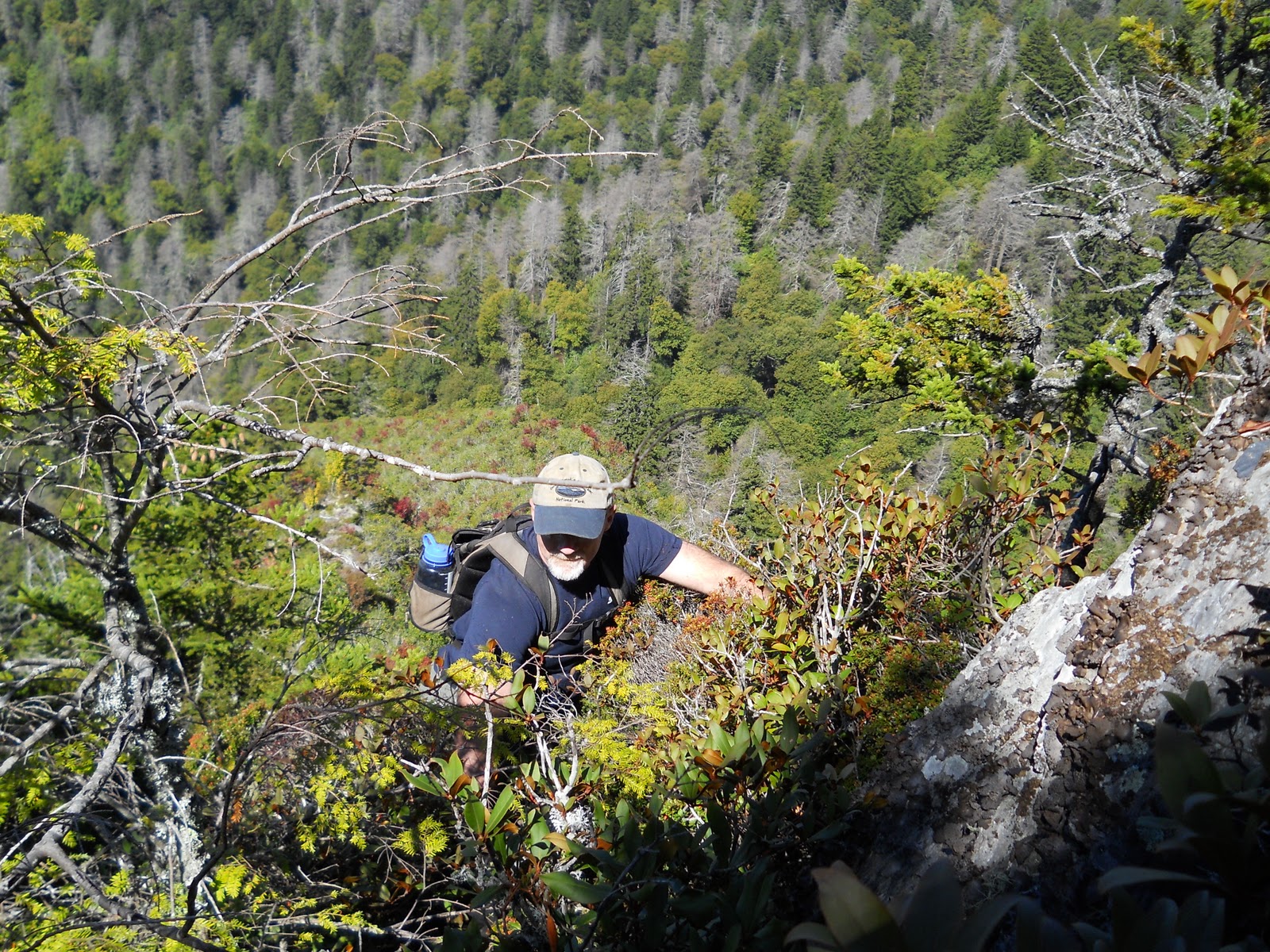
So on this crisp, clear March day, we parked Greg’s car at the parking spot where Walker Camp Prong flows off the slopes of Mount Kephart and under Newfound Gap Road and began walking up the side of that nameless side spur of Anakeesta Ridge. Our hike to the ridgecrest would be steep, which became immediately apparent. Greg’s calculations (he’s the statistician on all our hikes) showed that we would ascend from 4,600 feet to 5,600 feet in 3/10 of a mile. Yes, 1,000 feet vertical in .3 mile horizontal. Compare that to the typical Smokies trail which rises 500 feet in 1 mile.

I never know what to call this type of hike. I tend not to use the word “climb” because the rock climbers with ropes and carabiners are the ones who “climb.” On the other hand, the word “hike” implies walking upright on two feet. The first hour of this hike was somewhere in between. We’d walk steeply but upright for awhile, then we’d switch to hands and feet, using rocks, roots, and limbs to pull ourselves up. I’ve heard people use the word “scramble” to describe this, but somehow that sounds quick and energetic, which definitely doesn’t apply here.


Whatever it was we were doing, it wasn’t dangerous, but it was dirty and slow. [To be continued]

Wednesday, March 23, 2011

The Anakeesta Triangle (Part 1 of 5)

It’s amazing to me that people will pay $20 or $30 to stand in line for an hour for the opportunity to be jostled and scared by a roller coaster, but they’ll run indoors if it starts to rain for free. They don’t want to get wet; although, I’m sure the threat of lightning also has something to do with it. And they have statistics to back them up – more people are killed by lightning than are killed on roller coasters every year. I’m so certain of that, I didn’t even bother to look it up, so I have no source for my conclusion other than the fact that CNN has not reported any roller coaster accidents lately. (The conflict in Iraq? Nothing to report. Slaughter in Sudan or Congo? Not interested. Shark attacks and roller coaster accidents? Now that’s news!)

I suppose the real reason for the appeal of thrill rides and fear of thunderstorms is lawyers. They can help you sue Six Flags but not Mother Nature. The lawyers know this; the tourists know this; and, most importantly, the folks who run the amusement parks know this. And that’s why so few people are killed on roller coasters. The folks who own them make sure that they aren’t really dangerous. They stay on their tracks. The riders are buckled and strapped in. Thus, the thrill without any real danger. You scream while you ride these things, but you know you are safe. And if you do get hurt, you and your lawyer will sue the pants off Six Flags.

Thunderstorms are, of course, different. There’s no one out there overseeing their construction to ensure safety and quality control. If you find yourself caught outside in a thunderstorm, you can’t squeal and laugh, knowing deep down inside that you are safe. In fact, it’s just the opposite. Most of us, including those guys who boldly ride the amusement park rides, will cower in a ditch or beside a rock during a thunderstorm, knowing deep down inside that this thing could kill us.

Of course, you’ve heard that your car is a safe space during a thunderstorm, and as far as I can tell, that’s not just an urban legend. So, if you are ever caught in a heavy rainstorm in the Smokies, just pull off the road, stay in your car, and enjoy the show. If you’ll do that, it will be like the roller coaster – all thrill, little danger (except to the electrical system of your car). But there’s one important stipulation here: don’t park on Newfound Gap Road between the Chimneys Tops Trail and Newfound Gap. The water and lightning probably won’t get you, but the mud, trees, and boulders might.

There’s an area of the park that has been especially susceptible to flash floods and landslides. They don’t happen often – maybe one major event every decade – but when they do, they are impressively dangerous. This danger zone runs roughly from the Chimney Tops trailhead along the main ridge of Mount LeConte and the Boulevard to Charlies Bunion, then west along the main crest to Sugarland Mountain, and down the spine of Sugarland Mountain to the Chimney Tops. Or, another way of saying it: the upper watershed of the West Prong of the Little Pigeon River, consisting of Walker Camp Prong and Road Prong, plus their numerous tributaries.

The heart of this triangle of danger is Anakeesta Ridge, which is easily recognizable from the road. It’s the one that’s missing big chunks of soil and vegetation on its high slopes. These rocky scars are seen clearly from the top mile or two of the road leading from Gatlinburg to Newfound Gap. Stop at one of the parking pullouts near Morton Overlook and look north across the valley. That beaten and bruised ridge with exposed, rocky scars is Anakeesta Ridge. (Behind it lies Mount LeConte; also bruised and scarred.) It’s weathered but still standing, yet it seems to be evolving in the opposite direction from most mountains. We’ve all heard that the Rocky Mountains are young, but the Smokies are older, having that smoothed, rounded, ancient look. As time passes, mountains are supposed to become softer and gentler. Apparently, Anakeesta Ridge didn’t get that memo. It has shed huge slices of soil and trees, exposing steep, rocky scars that would look at home west of Mississippi.


 [To be continued]

Tuesday, March 8, 2011

Albright Grove: No Tree Lives Forever (Part 2 of 2)

As Phyllis and I walked through Albright Grove I wondered why this piece of virgin forest didn’t look established and mature, like a 300 year old cathedral.

After some rumination and a few conversations with a few folks who might know, I think I know at least part of the answer. Albright Grove has been slowly, invisibly “logged.”

Some of the logging has been the result of old age. Some trees species will live longer than others, but no tree can live forever. Throw pollution, lightning, wind, and drought into the mix and the result is an old forest with many dead, dying, and broken trees.

Other loggers were small and secretive. They snuck into our forest before we realized what was happening, and once we discovered their covert activity, it was too late. We were defenseless against their attack. This happened in the 1930s when the Chestnut blight (fungus) swept through the eastern US and wiped out virtually all of what had been one of the dominant trees in the East – the American Chestnut.

It was a biological and economic disaster for the animals and the people, both of whom depended on the chestnuts for their life and livelihood. Of course, the forests suffered, but as any biological community will do, it readjusted, filled in the gaps, and flourished in a different form. Where chestnut once dominated, we now see poplar, maple, oak, and hickory.

This tragedy happened about 75 years ago, which is a long time in human terms but not in forestry terms. The death of the chestnuts opened up the forest canopy. The sunlight shone down on the long-shaded forest floor, and the fight was on! Flowers, shrubs, and trees vied for position, creating a botanical chaos for a few years. Gradually, the trees grew up to take the place of the American Chestnuts, but the process is still unfolding. The deep, deep shade of a mature forest is still missing. The massive trunks of ancient trees are missing – except for the few, scattered giants still hanging on in Albright Grove and other portions of virgin forest in the Smokies.

What’s really going on here is the difference between a climax forest and virgin forest, two things that would often be the same thing but not always. Not in Albright Grove.

A virgin forest is one that has not been logged. It is untouched by man. This creates images in our heads of deep, dark forests of huge, old trees. An eastern, hardwood version of those huge, open redwood and sequoia forests of the Pacific coast. What we are visualizing is actually a climax forest – that ultimate stage of a centuries-long process of plant succession. It’s plant succession that is still unfinished in the disturbed forest of Albright Grove.

Plant succession is an interesting process. You see it every September as your family’s vegetable garden winds down for another year, and the grass and weeds creep in. You see it whenever a farmer stops tilling or cutting his field. Almost immediately weeds and shrubs begin their invasion, followed quickly (here in East Tennessee) by the cedars and pines. These are the “pioneer species” because they are the first to arrive. Interestingly, these pioneers create the conditions for their own demise by creating shade and soil changes that enable other species to grow. If the land is sunny and dry then the pines will dominate. If the location is moist and cool then after a few decades, hardwoods will replace the pines. The only question is which species of hardwood will win the battle – Maple? Hickory? Oak? That, too, depends on elevation, moisture, soil type, plus a little bit of random luck.

It’s an evolution of sorts but not the type that Darwin wrote about. It’s not the evolution of a species; it’s actually an evolution (or “development,” if you prefer that word) of the relationships between species. If this was a human community, it would be studied by sociologists, but since it’s plants and animals, the folks who study it are ecologists. Either way, it’s a community that is developing, a botanical and zoological community.
This process of plant succession continues for hundreds of years until this forest community reaches maturity, the climax, usually a deeply shaded forest with a high canopy and shade-loving plants on the forest floor. It’s the cathedral that Phyllis and I were expecting as we stepped off Maddron Bald Trail and onto Albright Loop Trail.

So now, with your expectations adjusted – not necessarily lowered, just adjusted – you can spend four or five hours enjoying the beauty of this part of the park. Go and enjoy this old, virgin, evolving forest. Just remember that it’s a changing forest community, not a cathedral. At least, not yet.

Monday, February 14, 2011

National Park Hyperbole (Part 1 of 2)

Every now and then, something unusual happens: my time in the Smokies doesn’t live up to my expectations. That happened to me recently in Albright Grove.

If there’s one lesson I’ve learned over the years, it is this: the secret to happiness in life is lowering your expectations. I usually say this as a joke, and yet it’s amazing how often it fits the circumstances, on an almost daily basis. Job, sports, health, relationships, teenagers, our political leaders… the list goes on. So maybe it’s not a joke after all. There must be some truth to it. If you aren’t convinced, consider the Vols’ last few football seasons or your 401(k).

Maybe Albright Grove belongs in this list…

After buying some apples and honey at Carver’s Applehouse in Cosby on a crisp October Saturday (very early October, before the deluge of leaf-watchers struck), Phyllis and I turned onto Baxter Road and wound around to the trailhead of Maddron Bald Trail. There’s room for only 3 or 4 cars here, but today that was plenty. So we shouldered our daypacks and walked past the gate and up the trail. Up is the right word here, but with no exclamation points or capital letters. This trail is wide and well-maintained, and its incline is unrelenting but “moderate,” to quote the trail guide. Yes, it’s that 500’ rise per mile that is very common in the Smokies. That was clearly the gradient of choice in the 1930s when the CCC built these trails. I’ve sometimes wondered if the trails were being built today whether the builders might choose a milder incline because we are today a softer, more delicate people than 75 years ago. Still, 500 feet per mile is manageable, even for those of us who were born in the mid 20th century.

Phyllis and I moseyed our way up the trail, stopping often to examine flowers, leaves, stumps, red squirrels, juncos, even an old cabin. As usual, the surroundings were pleasant. The weather was fabulous. The occasional glimpse of nearby mountain tops showed that the colors of fall were just beginning the show at the highest elevations and would spend the next few weeks marching gradually down the slopes.

Our goal this day was Albright Grove, a portion of the park that is described in some of the park literature as a magnificent section of unspoiled virgin forest that escaped the logger’s axe. I don’t know what you visualize when you hear that, but I visualized a deeply shaded, mature forest with a high, thick forest canopy held aloft by huge trees. It would give the feeling of being in a cathedral with a high, vaulted ceiling. There would be some underbrush, but the shade would have choked out much of it. There would be a sense of openness and depth and peace. As one book says, “Being in the Albright Grove has the kind of effect that lingers in your memory for instant recall, soothes the spirit with profound quiet, gives nourishment to the soul.”

Okay, everyone is entitled to their opinion… and my opinion is that it’s time to lower your expectations. Most of those folks who have written glowing reports of Albright Grove have fallen victim to that dreaded disease – National Park Hyperbole. Its primary symptom is verbal exaggeration. It’s an affliction much like alcoholism or pollen allergies: once you’ve been stricken, you will battle it your entire life, sometimes resisting, sometimes succumbing. If a writer describes a view as “the best” or “the most dramatic” or some such superlative, you can be confident that he’s suffering from a case of NPH. Albright Grove seems to be a spot that triggers serious outbreaks of this affliction.

First, the huge, old trees. Yes, there are many bigger-than-average trees – the largest of which are sickly, some almost dead. I don’t mean to be crass here, but Albright Grove felt more like a nursing home than a cathedral. Those old, old trees surely had some stories to tell, probably going as far back as the Revolutionary War, but they seemed too sick to open their eyes and speak.

That’s not to say that the entire forest was sickly. On the contrary, it was, for the most part, healthy. That’s because most of the forest was young with various species of trees still struggling with each other for dominance. As we walked through the Grove I wondered why. Why not an old, established forest? Why not a cathedral? [To be continued]

Friday, February 4, 2011

The Great State of Denial

Yes, I live in the great state of Tennessee, but lately I’ve been spending an increasing amount of time in the great state of Denial. And that’s not necessarily a bad thing. As a matter of fact, I kind of like it there. It’s a place where I can do pretty much whatever I want…

As I walked back to the Forney Creek campsite after a late night paddle on Fontana Lake, I expected to crawl into my tent and sleeping bag and drift off to sleep. However, as I crunched though the leaves, I heard a voice: “Dad, is that you?”

Melissa was still awake in her tent. She asked how the paddle was, plus a few follow-up questions. After a minute, John filled in the missing information: “She’s wearing me out! She was worried about you and was about to make me go look for you.”

At first I just chalked Melissa’s worry up to the fact that she’s a caring, sensitive person. And, because she’s like her mother, that’s true. But there was really nothing to be worried about. Paddling at night might get you wet, but it won’t get you killed. And in this case, neither happened. So, why was Melissa worried?

I think it has something to do with my new residence in the state of Denial. Melissa and my wife often worry about me on my outdoor excursions. I think they worry too much, but maybe they have good reason. I’m having trouble acting my age, which is perfectly legal in the state of Denial. I continue to do the same things that I’ve been doing for the past 30 years. In fact, I’m probably doing even more outdoor activities than I used to do, because the clock is ticking. It gets louder and slower with each passing year.

A younger friend of mine has a pre-game mantra that his wife imposed upon him. He must repeat it before every recreation league basketball game: “I’m not 21 anymore. I’m not 21 anymore….” I probably need a similar ritual for the mountains, but it would be more depressing: “I’m not 40 anymore….”

My mind hasn’t fully grasped my new, age-imposed physical limitations. Most guys first notice this on the softball field or basketball court, but it shows up in the mountains, too. You just keep on doing things that you’ve always done, without admitting that you aren’t doing them as well or as quickly as you used to. This puts you into the realm of behavior that keeps your friends and family (especially those females that love you) awake and worried every time you go out into the woods. My jokes about dying nobly in the mountains tend to fall on deaf ears. None of the women in my life (i.e., my wife and daughter) think my death-in-the-wilderness jokes are funny.

When I was younger they worried that I’d do something stupid because I was young and thought I was invincible. Now they worry that I’ll get hurt while simply walking on a trail or climbing onto a river rock. When I do get seriously injured, it won’t be from doing something incredibly stupid; it will happen by doing something that is safe and sensible – for a guy in his 20s or 30s, but maybe not for a guy in his 50s. When I end up with broken bones or dehydrated from exposure, and someone asks me what happened, my short answer will be: “Not acting my age.” Learning to act my age is a lesson I’m still resisting – thus the worried women.


But, bless their hearts, they’ve always just smiled and said, “Have fun and be careful.” They haven’t yet tried to stop me from playing in the rivers, ridges, woods, and lakes. They understand that an old guy’s gotta do what an old guy’s gotta do. Even if he can’t do it as well as he used to.


So if you’d like to spend some time in the state of Denial, just let me know, and I’ll give you directions. It’s a nice place to visit (although, the accident and injury rates are pretty high). In fact, I intend to spend my retirement years there, if I can get Phyllis to agree to the move.

Wednesday, January 19, 2011

Peregrine Homecoming (Part 3 of 3)

When I first heard the name “duck hawk,” I visualized some sort of hybrid bird – a mix of a hawk and a duck. It’s not a very majestic image – maybe a hawk with a big, Daffy Duck beak or a big butt better suited for floating than soaring – but all that changed when I learned that “Duck Hawk” is just a quaint, old name for a peregrine falcon. I didn’t know much about falcons, but my image of them was sleek, fast hunters who live by catching and killing other animals. That put them in the same category as eagles and hawks which is pretty elite company if we’ll ignore the fact that eagles frequently feast on dead, rotting fish, the aquatic equivalent of roadkill.

There are three main falcons in the eastern US: American kestrel, merlin, and peregrine falcon. These three are sleek, modest-sized birds with black-and-white face markings like the rock band Kiss. The kestrel and merlin are about the size of a blue jay while the peregrine is about six inches longer, about the size of a healthy crow. I’ll occasionally see an American kestrel sitting on a power line overlooking a field. They have rusty-orange colored backs and those distinctive Kiss face markings. Merlins are rare in our area, passing through occasionally during spring and fall migrations.

Peregrine falcons are permanent residents in the eastern US. In fact, they are permanent residents across almost the entire planet, being one of the most widely distributed animals in the world. But that doesn’t mean they are common. There are only three well-documented, breeding pairs in Tennessee: one on Little Duck Hawk Ridge, one near Charlies Bunion, and another pair at the Chickamauga Dam in Chattanooga. (Personally, I’d bet there are one or two more couples in the Smokies that the NPS isn’t telling us about to protect their privacy.) The owners of Rock City are participating in a falcon “hacking” (the release of captive falcons) program at Lovers’ Leap, so if that project is successful, it will give us another reason to See Rock City.

Ironically, aside from the banning of DDT, the other factor that has strongly contributed to their comeback has been big cities with tall buildings. For example, the first nesting pair of peregrines in the state of Ohio was found in Toledo in 1988; afterwards, they spread to Cincinnati and Cleveland. Chicago and Indianapolis both have peregrine families living in their downtown areas. Not very inspiring stuff. In my mind, that diminishes the glamour of these birds a bit because they appear to occupy the same environmental niche as pigeons, their favorite food.

I’d prefer that they live only in wild, lonely places that are hard to find, but that isn’t how Mother Nature and urban architects wrote the script. They nest on rocky cliffs and ledges, but apparently the concrete walls of bridges, dams, and skyscrapers fit that description well enough to satisfy the falcons. The fact that cities lack the primary predator of falcon chicks – the Great Horned Owl – also makes high-rise, urban areas favorable falcon habitat.

Beside their near extinction, peregrines’ other claim to fame is their speed. On a good, downward dive toward their prey, they can reach speeds of 200 mph, making them the fastest animal in the world. In the wild, these falcons will swoop down like a dive bomber and crash talons-first, mid-air into their prey. They seem to prefer birds that fly in flocks rather than alone, so it’s like shooting fish in a barrel, which isn’t very sporting but is ruthlessly efficient, which is what falcons do.

They have been captured and trained for at least three thousand years, and in the days before guns, they were a useful way of hunting birds. During the Middle Ages in Europe, falconry became “the sport of kings,” a form of entertainment for the elite, perhaps arising from the fact that falcons would sometimes nest on the walls of Medieval castles and cathedrals; although, the fact that only the wealthy nobility would have the leisure time to pursue sport of any kind would also have been part of the equation. So, in spite of their penchant for eating urban pigeons, they do have a trace of nobility in their blood.

So, as we stood at a wide spot on Big Duck Hawk Ridge, looking upon the southern slopes of Mount LeConte, near Peregrine Peak, the Duck Hawks made their appearance. The entire show lasted only 5 minutes, but it was the grand finale to an already fine day. We had grandstand seats for a brief, simple encore by a couple of birds, but it was a show that had been repeated for hundreds or thousands of years, at this very spot with no human witnesses, and then had come to a sudden, almost-permanent halt.

We didn’t see them fly with mind-boggling speed. They didn’t capture any prey. They simply circled and soared, enjoying the fact that they were home again, alive and well in a beautiful place – exactly as God had intended.


Website only
In this article I mentioned two “well documented” breeding pairs in the Smokies, but that might not be exactly true. The family on Little Duck Hawk is well documented and even advertised. I’ve seen an occasional reference in NPS literature about the falcons on this ridge. The second pair near Charlies Bunion is a bit more enigmatic. In the fall of 2010 several of us on a ridge just east of Charlies Bunion witnessed three peregrine falcons harass and attack a hawk that had soared into their territory between us and the Bunion. (It was a great bird-watching moment for all of us; even the non-bird-watchers among us were greatly impressed.) From what I’ve read, protecting territory is “consistent with nesting behavior.” So we definitely saw three peregrines in the area – at one point, they flew right over our heads, within about 50 feet; we could even hear the wind in their wings as they turned and dove – but we don’t really know for certain that they are nesting in the area, nor do we know if the NPS has actually studied them to determine if they are nesting and reproducing. In fact, I’ve never seen any official mention of them. But they are definitely there.

There’s also talk of a pair of peregrines that were spotted in 2003 near the cliffs at the western end of Greenbrier Pinnacle, in the area called the Cat Stairs. I’ve also been told that the trail to the top of Greenbrier Pinnacle was closed sometime in the 1980s because of a “hacking” program that was being carried out at that time. (Hacking is raising the falcons in captivity and then releasing them into the wild, hoping they’ll survive, nest, and reproduce.) I’ve spent a good bit of time in this area of the park – it’s one of my favorites – but I’ve never seen falcons there.

Because this part of the park is difficult to access, and because it’s one of my favorites, I desperately want the falcons to be there. So, I intend to spend some good, quality time there in the next few years, keeping my eyes open and looking up. The fact that peregrines have a distinctive call while flying means that I’ll keep my ears open, too.

So if you visit Alum Cave or Charlies Bunion (or Greenbiar Pinnacle), keep your eyes and ears open. With a little luck you’ll see one of the best aerial displays this side of the Mississippi.


Big Duck Hawk Ridge (Part 2 of 3)

Ever since our recent trip to the top of Mount LeConte, my friends had been talking incessantly about exploring Big Duck Hawk Ridge on LeConte’s south slope. The views from Alum Cave Trail of Big Duck Hawk Ridge had been enticing. It looked rugged and rocky and, therefore, worthy of inclusion on our To Do Soon list. The fact that peregrine falcons are nesting on nearby Little Duck Hawk Ridge made this section of the park doubly appealing. I had never seen one of these rare falcons before, so my hopes were high that they’d make an appearance.

Big Duck Hawk Ridge from Alum Cave Trail

I had been distracted by some of life’s obligations, so most of the thought and planning for our trip to Big Duck Hawk had been done by my hiking partners, not me. I’ve been the planner and navigator on many family vacations ever since I was young, so I’m not used to just showing up and having a map and itinerary handed to me, but that’s what happened on this trip. As we stepped out of Greg’s car he gave me a topo map with a blue line showing our intended route. We would start at the Alum Cave Trail parking lot but would immediately hop off the trail, cross the river, and work our way up the south side of Big Duck Hawk to its ridgecrest. We would then follow the crest north and east to its junction with Alum Cave Trail near Alum Cave Bluff. It was pretty much the same route that I would have chosen, so there were no great surprises or debates about the route, but I felt a bit bewildered as we started simply because I hadn’t spent a few days ruminating about the pros and cons of the various routes that we could choose from.

After crossing the creek, we immediately dove into a rhododendron thicket that was actually more help than hindrance. It was thick and low enough to force us to weave and crawl, but the branches provided convenient handles for us to grab as we slithered our way up the steep slope. It’s not at all unusual after a hike like this for our arms and backs to be just as tired as our legs.

Without going into all the gory details, I’ll make a long story short by saying that we spent a lot of time thrashing against walls of brier, bushes, and vines on this small side ridge. At one point I actually found myself looking for a rhododendron thicket because that would be easier terrain. Yes, you know you are having a rough day when a rhododendron hell is the easy route.

The wisest words of the day were spoken by Greg Harrell, when he said, “You guys know I love hiking up ridges, but it’s time to try something new….” So we bailed out of our intended path and found a tiny creek to follow. Hiking up these slippery ravines is not easy, but they often provide a much needed reprieve from the brush and thickets that can form impenetrable green walls. It was a good choice. This small creekbed led us to the crest of Big Duck Hawk Ridge, maybe a tenth of a mile east of our original route.


The crest was exactly what we’ve come to expect of these obscure side ridges in this part of the Smokies: narrow, rocky spines adorned with mountain laurel, sand myrtle, and gnarled spruce and table mountain pines. And the views were fabulous, even though we were only about 4,800’ high. There were plenty of ridges and peaks that were higher than we were, but there’s something about being totally alone on a rarely-visited ridge that makes us feel like we are on the top of the world. These rocky ridges are, in our opinion, one of the great, undisclosed secrets of the Smokies. There are few, if any, official trails that lead to settings such as this. The reason for the secrecy is obvious: these rocky ridges are too fragile and risky to advertise to the general public. There would be too much damage done to both the landscape and the tourists.


It’s a sign of a good trip when most of your stops are for the scenic views, not for resting and recuperating. So this was a good trip. As we sat on a rocky spot surrounded by the ridges and valleys of Mount LeConte, Anakeesta Ridge, and Sugarland Mountain, we looked up and ahead toward our junction with Alum Cave Trail. It was appropriate that the name of the peak where we were headed was Peregrine Peak because that was where we caught a glimpse of them – a pair of falcons circling their domain between Big and Little Duck Hawk Ridges.


[To be continued]